Posts

Showing posts from October, 2013

NINE FLOATING FOUNTAINS, JAPAN

Image
It'a not an optical illusion, but it is a good example of how to think differently from others. Isamu Noguchi last work for the world expo in Osaka, japan is “Nine floating Fountains”. He expanded water tap illusion one step further to create incredible fountains that looks like they are actually flying.

BEACHY HEAD, ENGLAND (SUICIDE SPOT)

Image
Beach head is located in the country of East Sussex near the town of Eastbourne. It is the highest chalk sea cliff in Britain. Beachy head rises 531 feet (162 metres) above the sea level. Beachy head is famous for beautiful view which can be seen from the cliff top. But this beautiful site is also notorious as a suicide spot because of its height. It has been estimated that on average 20 people commit suicide on this spot in an year. The Beachy Head Chaplaincy Team conducts regular patrols of the area in attempts to find and stop potential jumpers.

El Peñón de Guatapé (The Rock of Guatape)

Image
The Rock of Guatapé" is a massive formation located at the town and municipality of Guatapé, one kilometre inside the city limits in Antioquia, Colombia.

RESTAURANT IN AIR PLANE

Image
There is a restaurant is Costa Rica which is build inside a 1965 Boeing 727 airplane. This restaurant is situated on the edge of the Manuel Antonio National Park. The airplane has now become a two bedroom suite perched on the edge of the rainforest overlooking the beach and ocean.

BALL'S PYRAMID

Image
Ball's pyramid is the remains of shield volcano which was formed about seven million years ago. It is the world's tallest sea stack. Its height is 1844 ft (562 metres) and is located south-east of Lord Howe island in the Pacific ocean.

THE DEVIL'S TRIANGLE (PACIFIC BERMUDA TRIANGLE)

Image
This area is considered as Bermuda triangle of the Pacific ocean. The Devil's sea is notorious for mysteriously disappearing of aircraft and ships. It was stated that in the peacetime years between 1952-54 Japan lost five military vessels with crews lost totalling over seven hundred people and that the Japanese government sent a research vessel with over one hundred scientists on board to study the Devil's Sea, and that this ship too disappeared; and finally the area was officially declared as a danger zone.

UNDERWATER PYRAMID

An ancient pyramid that was found fourteen thousand feet underwater with a mysterious crystal.

THREE GORGES DAM

Image
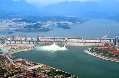
The Three Gorges Dam is the largest hydroelectric dam in the world in terms of installed capacity (22,500 Mega Watt). It is located in the middle of the three gorges on the Yangtze River, in the Hubei Province of China. The project was approved by the Chinese government in 1992 but construction didn't begin until 1994. It was scheduled to be completed by 2009. Except for a ship lift, the dam project was completed and fully functional as of July 4, 2012. The $25 billion project is being internationally funded by companies, export credit agencies, and banks from Canada, Switzerland, Germany, France, Sweden, and Brazil. This mega-structure sets records for number of people displaced (more than 1.2 million), number of cities and towns flooded (13 cities, 140 towns, 1,350 villages), and length of reservoir (more than 600 kilometres). The dam also flooded archaeological and cultural sites

10- ANNAPURNA

Image
Annapurna is a part of the Himalayas in north-central Nepal that includes  26,545 ft  ( 8,091 meters ) Annapurna I, thirteen additional peaks over  22,970 ft  ( 7,000 meters ) and 16 more over  19,690 ft  ( 6,000 meters ). This section is a 55 kilometre-long massif bounded by the Kali Gandaki Gorge on the west, the Marshyangdi River on the north and east, and Pokhara Valley on the south. Annapurna I is 10th among Earth's fourteen eight-thousanders. 8167 metre Dhaulagiri I rises thirty four kilometres to the west across the Kali Gandaki Gorge, which is the Earth's deepest canyon. Annapurna is a Sanskrit word which literally means "full of food" (feminine), but is normally translated as Goddess of the Harvests. In Hinduism, Annapurna is the mother who feeds. Her most popular shrine is located in Kashi, on the banks of the river Ganga." Her association with the giving of food or wealth led her in time to be transformed into Lakshmi, the Goddess of Wealt

9- NANGA PARBAT (Killer Mountain)

Image
Nanga Parbat is the 9th highest mountain in this planet. It is the western anchor of the Himalayas around which the Indus river skirts before it debouches into the plains of Pakistan. Nanga Parbat means naked mountain. It is situated in the Gilgit-Baltistan region of Pakistan. Nanga Parbat is one of the eight-thousanders, with a summit elevation of 26,660 ft (8,126 metres). An immense, dramatic peak rising far above its surrounding terrain, Nanga Parbat is also a notoriously difficult climb. Numerous mountaineering casualties in the mid and early twentieth century lent it the nickname "killer mountain". This mountain has never been climbed in winter.

8- MANASLU

Image
Manaslu (also known as Kutang) is the 8th highest mountain in this planet, and is situated in the Mansiri Himal, part of the Nepalese Himalayas, in the west-central part of Nepal. Manaslu means "Mountain of the Spirit", comes from the Sanskrit word Manasa, meaning "soul" or "intellect". Manaslu was first climbed on 9th May, 1956 by Gyalzen Norbu and Toshio Imanishi, members of a Japanese expedition. It is said that "just as the British consider Mount Everest their mountain, Manaslu mountain has always been a Japanese mountain". Manaslu at 26,759 ft (8,156 metres) above mean sea level is the highest peak in the Lamjung District and is located about 40 miles east of Annapurna. The mountain's long ridges and valley glaciers offer feasible approaches from all directions, and culminate in a peak that towers steeply above its surrounding landscape, and is a dominant feature when viewed from afar. The Nepalese Government only permitted tre

7- DHAULAGIRI

Image
The mountain's name is धौलागिरी (dhaulāgirī) in Nepali language. This comes from Sanskrit where धवल (dhawala) meaning is dazzling, white, beautiful and गिरि (giri) meaning is mountain. Dhaulagiri I is the highest point of the Gandaki river basin. The Dhaulagiri massif in Nepal extends 120 km from the Kaligandaki River west to the Bheri. This massif is enclosed on the north and south-west by tributaries of the Bheri and on the south-east by Myagdi Khola. Dhaulagiri I at  26,795 ft  (8,167 metres) ranks seventh among world's 14 peaks over 8 thousand metres. It was first climbed on 13th May 1960 by a Swiss/Austrian/Nepali expedition.

6- CHO OYU

Image
Cho Oyu is the 6th highest mountain in the world at 26,906 ft (8,201 metres) above sea level. Cho Oyu means "Turquoise Goddess" in Tibetan. The mountain is the westernmost major peak of the Khumbu sub-section of the Mahalangur Himalaya 20 kilometres west of Mount Everest. This mountain is located at the Tibet-Nepal border. Just a few kilometres west of Cho Oyu is Nangpa La (18,753 ft), a glaciated pass that serves as the main trading route between the Tibetans and the Khumbu's Sherpas. This pass separates the Khumbu and Rolwaling Himalayas. Due to its proximity to this pass and the generally moderate slopes of the standard northwest ridge route, Cho Oyu is considered the easiest 8,000 metre peak to climb.

5- MAKALU

Image
Makalu is the 5th highest mountain in the world at 27,825 ft (8,481 metres) and is located 19 km southeast of Mount Everest, on the border between Nepal and China. Makalu is an isolated peak whose shape is a four-sided pyramid. Makalu has two notable subsidiary peaks. Kangchungtse, or Makalu II (7,678 meters) lies about 3 km north-northwest of the main summit. Rising about 5 km north-northeast of the main summit across a broad plateau, and connected to Kangchungtse by a narrow, 7,200 meters saddle, is Chomo Lonzo. Makalu was first climbed on 15th May 1955 by Lionel Terray and Jean Couzy of a French expedition led by Jean Franco. Franco, G. Magnone and Sardar Gyaltsen, Norbu summitted the next day, followed by Bouvier, S. Coupe, Leroux and A. Vialatte on the 17th May 1955.

4- LHOTSE

Image
Lhotse is the 4th highest mountain in the World and is connected to Everest via the South Col. Lhotse means “South Peak” in Tibetan. In addition to the main summit at 27,940 ft (8,516 metres) above sea level, Lhotse Middle (East) is 27,605 ft (8,414 meters) and Lhotse Shar is 27,503 ft (8,383 meters). It is located at the border between Tibet (China) and the Khumbu region of Nepal. Lhotse's south face rises 3.2 km in only 2.25 km of horizontal distance, making it the steepest face of this size in the world. The south face has been the scene of many failed attempts, some notable fatalities, and very few ascents.

3- KANGCHENJUNGA

Image
Kangchenjunga is the third highest mountain in the world, with an elevation of 28,169 ft (8,586 meters) in a section of the Himalayas called Kangchenjunga Himal that is limited in the west by the Tamur River and in the east by the Teesta River. Kangchenjunga is located on the boundary between Nepal and the Indian state of Sikkim. It is the highest peak in India and the easternmost of the peaks higher than 26,000 ft (8,000 meters). It is called Five Treasures of Snow after its five high peaks. This mountain has always been worshiped by the people of Darjeeling and Sikkim. Until 1852, Kangchenjunga was considered to be the highest mountain in the world, but calculations based on various readings and measurements made by the Great Trigonometric Survey of India in 1849 came to the conclusion that Mount Everest was the highest mountain. It was officially announced in 1856 that Kangchenjunga is the third-highest mountain. Kangchenjunga was first climbed on 25 May 1955 by Joe Brow

2- K2

Image
K2 is also known as Chhogori/Qogir, Ketu/Kechu, and Mount Godwin-Austen. It is the second-highest mountain on Earth, after Mount Everest. It is located on the border between Baltistan, in the Gilgit–Baltistan region of northern Pakistan, and the Taxkorgan Tajik Autonomous County of Xinjiang, China. It has a peak elevation of 28,251 feet (8,611 meter). K2 is the highest point of the Karakoram Range and the highest point in Pakistan. K2 is known as the Savage Mountain due to the extreme difficulty of ascent and the second-highest fatality rate among the eight thousanders. For every four people who have reached the summit, one has died trying. It is more hazardous to reach K2 from the Chinese side; thus, it is mostly climbed from the Pakistani side. Unlike Annapurna, the mountain with the highest fatality-to-summit rate, K2 has never been climbed in winter.

1- MOUNT EVEREST

Image
Mount Everest it the Earth's highest mountain, with a peak at 29,029 ft (8,848 meters) above sea level and the fifth tallest mountain measured from the centre of the Earth. Its location is in the Mahalangur section of the Himalayas. Mount Everest attracts many highly experienced mountaineers as well as capable climbers willing to hire professional guides. There are two main climbing routes, one approaching the summit from the southeast in Nepal (known as the standard route) and the other from the north in Tibet.    While not posing substantial technical climbing challenges on the standard route, Everest presents dangers such as altitude sickness, weather, wind as well as significant objective hazards from avalanches and the Khumbu Icefall. While the overwhelming majority of climbers will use bottled oxygen in order to reach the top, some climbers have summitted Everest without supplemental oxygen.

10- Browne Falls

Image
Browne Falls is a waterfall above Doubtful Sound, which is located in Fiordland National Park, New Zealand. It is the 10th tallest waterfall on earth. In a temperate rain forest, the falls cascade down to the fiord near Hall Arm. Heights of 619 metres and 836 metres have been given for the falls. Their source is a tarn called Lake Browne (836 meter above sea level) which when full, overflows down the side of the mountain face. The stream makes 836 meter height difference over 1,130 meter horizontal difference, thus the mean gradient of stream is 42 degrees. This comparatively low angle makes falls less impressive. The falls are named after pioneering aerial photographer, Victor Carlyle Browne, who discovered Lake Browne and the associated falls on one of his flights over Fiordland in the 1940s.

9- JAMES BRUCE FALLS

Image
James Bruce Falls is the highest measured waterfall in the continent of North America and ninth tallest in the world.  Located in Princess Louisa Marine Provincial Park in British Columbia, Canada, it stems from a small snowfield and cascades 840 meters (2,755 feet) down to Princess Louisa Inlet. Two parallel streams, for which the falls are named, come from this snowfield, one of which is persistent throughout the year and the other of which usually dries up by July. The stream flows into Loquilts Creek, which empties into the inlet via the better known Chatterbox Falls.

8- PU'UKA'OKU FALLS

Image
Pu'uka'oku Falls is the eight highest waterfall on earth with the height of 840 meters (2756 feet). It is located in Hawaii state of United States.

7- BALAIFOSSEN

Image
Balåifossen is a waterfall in the river Balåi in Ulvik municipality of Hordaland , on the southeast side of Osafjorden . It has three vertical and the longest of which is 452 meters. The falls are mainly water from melting snow on Kyrelvfjellet over the falls, and it can therefore be completely dry in summer and autumn. The falls are best viewed from the road on the other side of the fjord. Balåifossen has a total drop of 850 meters, and according to the World Waterfall Database thus the second highest waterfall in Norway and Europe, and the seventh highest waterfall in the world.

6- VINNUFOSSEN

Image
Vinnufossen is the tallest waterfall in Europe and the sixth tallest in the world. The waterfall is located just east of the village of Sunndalsøra in the municipality of Sunndal in Møre og Romsdal county, Norway. The falls are part of the river Vinnu which flows down from the Vinnufjellet mountain and it is fed from the Vinnufonna glacier. The falls flow into the river Driva near the village of Hoelsand.